![[Click to enlarge image]](tn_002.jpg)
|
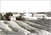
Scene in sandbanks, Hempstead Harbor, N.Y.,
c. 1900
Photo courtesy of Cow Neck Peninsula Historical
Society
|
![[Click to enlarge image]](tn_004.jpg)
|
"JS" and "HEW"on bluff
near Tom's Point, Port Washington, N.Y., 1903
Photo courtesy of Cow Neck Peninsula Historical
Society
|
![[Click to enlarge image]](tn_006.jpg)
|
Glenwood Landing, N. Y., sandbank diggers,
1897
Photo courtesy of Suffolk County Historical
Society
|
![[Click to enlarge image]](tn_019.jpg)
|
Cliffs reached heights of 200' in some places,
revealing sections of glacial delta. King's Pit, Hempstead
Harbor, N.Y., 1910
Photo courtesy of Port Washington Public
Library
|
![[Click to enlarge image]](tn_031.jpg)
|
Aerial view of "Sand Alley" looking
west, showing most of the 1200 acres mined for sand and gravel
since before the turn-of-the-century at Hempstead
Harbor, N.Y., 1931
Photo courtesy of Port Washington Public
Library
|
![[Click to enlarge image]](tn_043.jpg)
|
Building sand tunnel for McCormack plant,
Port Washington, N.Y., c. 1940
Photo courtesy of Port Washington Public
Library
|
![[Click to enlarge image]](tn_047.jpg)
|
View of sandbanks' basins
Photo courtesy of Harvey Weber
|
![[Click to enlarge image]](tn_048.jpg)
|
Boulder bed, Hempstead Harbor sandbanks, N.Y.
Photo courtesy of Harvey
Weber
|
![[Click to enlarge image]](tn_049.jpg)
|
Sand cliffs
Photo courtesy of Harvey
Weber
|
![[Click to enlarge image]](tn_061.jpg)
|
Sand processing overview, 1950's
From bottom: sand is loaded onto conveyor belt, then crushed
and screened, goes into washing plant (top, middle), deposited
in raw storage, delivered under tunnel to barges for trip
to NYC.
Photo courtesy of Al Salerno
|
![[Click to enlarge image]](tn_068.jpg)
|
Standard gauge rail operation at the sandbanks,
1952
Photo courtesy of Arthur Raabe
|
![[Click to enlarge image]](tn_069.jpg)
|
Standard gauge rail operation at sandbanks,
1952
Photo courtesy of Arthur Raabe
|
![[Click to enlarge image]](tn_087.jpg)
|
Hempstead Harbor sandbank, cross-section,
1980
Photo courtesy of Mitch Carucci
|
![[Click to enlarge image]](tn_190.jpg)
|
Aerial view of sandbanks
Photo courtesy of Port Washington Public Library
|
![[Click to enlarge image]](tn_sk146g.jpg)
|
Drawing rendition of green washer plant, West Shore Road,
1982, by Donald Sclare
Courtesy of Donald Sclare
|
![[Click to enlarge image]](tn_sk147.jpg)
|
Drawing rendition of sandbank, with artist's caption reading
"Methods of mining sand have changed greatly since 1889
when Peter Gallagher began lowering the bluffs north from
Plum Point." Artist unknown, n.d.
Courtesy of Port Washington Public Library
|
![[Click to enlarge image]](tn_s017.jpg)
|
Geological view of the sandbanks
1910 United States Geodetic Survey
|
![[Click to enlarge image]](tn_s018.jpg)
|
Geological view of the sandbanks
1910 United States Geodetic Survey
|
![[Click to enlarge image]](tn_s019.jpg)
|
Geological view of the sandbanks
1910 United States Geodetic Survey
|
![[Click to enlarge image]](tn_s020.jpg)
|
Geological view of the sandbanks
1910 United States Geodetic Survey
|
![[Click to enlarge image]](tn_s029.jpg)
|
Color photograph of Colonial Sand
and Gravel plant #2 in the 1950's, taken by
retired worker, Vincent Bezmen
|
![[Click to enlarge image]](tn_s030.jpg)
|
Color photograph of Colonial Sand
and Gravel plant #2 in the 1950's, taken by
retired worker, Vincent Bezmen
|
![[Click to enlarge image]](tn_s031.jpg)
|
Color photograph of Colonial Sand
and Gravel plant #2 in the 1950's, taken by
retired worker, Vincent Bezmen
|
![[Click to enlarge image]](tn_s032.jpg)
|
Color photograph of Colonial Sand
and Gravel plant #2 in the 1950's, taken by
retired worker, Vincent Bezmen
|
![[Click to enlarge image]](tn_s033.jpg)
|
Color photograph of Colonial Sand
and Gravel plant #2 in the 1950's, taken by
retired worker, Vincent Bezmen
|
![[Click to enlarge image]](tn_s034.jpg)
|
Color photograph of Colonial Sand
and Gravel plant #2 in the 1950's, taken by
retired worker, Vincent Bezmen
|
![[Click to enlarge image]](tn_s035.jpg)
|
Color photograph of Colonial Sand
and Gravel plant #2 in the 1950's, taken by
retired worker, Vincent Bezmen
|
![[Click to enlarge image]](tn_s036.jpg)
|
Color photograph of Colonial Sand
and Gravel plant #2 in the 1950's, taken by
retired worker, Vincent Bezmen
|
![[Click to enlarge image]](tn_s037.jpg)
|
Color photograph of Colonial Sand
and Gravel plant #2 in the 1950's, taken by
retired worker, Vincent Bezmen
|
![[Click to enlarge image]](tn_s038.jpg)
|
Color photograph of Colonial Sand
and Gravel plant #2 in the 1950's, taken by
retired worker, Vincent Bezmen
|
![[Click to enlarge image]](tn_s053.jpg)
|
View of Hempstead Harbor from Roslyn, with
Port Washington's sandbanks in the background, 1840
Courtesy of The Bryant Library, Local History
Collection, Roslyn, New York
|
![[Click to enlarge image]](tn_s060.jpg)
|
Sand washer, sand bank, Hempstead Harbor,
n.d.
Photo courtesy of M. Ries
|
 |
Sandscapes,
1983
(Click
on image to view entire gallery)
36 Images in gallery
Port Washington
photographer Dorothea Hahn penetrates the lands and environs
of the sandbanks to reveal a "bird's eye view" of
the state of the vegetation, soil, views, constructions and
geological features along West Shore Road in 1983. Her documentary
record helps contrast current conditions with those that existed
nineteen years ago.
|
.jpg) |
Virtual
Field Trip, c. 1985
(Click
on image to view entire gallery)
37 Images in gallery
Found
in a Reference Room file at the Port Washington Public Library,
these color snapshots are from a larger collection that sheds
light on the now-unreachable areas in and around the West
Shore Road sand embankments.
|